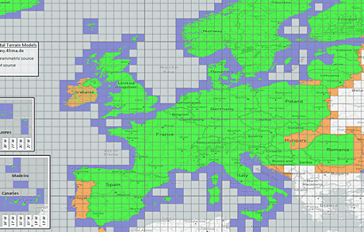
SONNY's LiDAR DIGITAL TERRAIN MODELS of EUROPE
 Compiled and resampled by Sonny

Welcome to my Website! I am a geographic enthusiast from Austria and back in 2016 I started collecting and compiling free Digital LiDAR Terrain Models ("DTMs").
I spent Hundreds of hours during my leisure time to search for new Opendata source files, get in contact with national public authorities and to download those giant amounts of data. Further to search for errors, plug gaps within the data, compile, resample it and create files in useful formats.
And finally to provide them to you, FOR FREE. Since I'm not a professional I appreciate, if you honor my voluntary work by supporting me with a Donation - Thank you very much!
If you don't want to use PayPal, you can also donate via bank transfer, just ask for my account details.
NEWS
- 2023-04-14: Norway_Mainland v2, Norway_Svalbard v1, Norway_Jan Mayen v1, Denmark_Faroes v1, United Kingdom v2, Ireland v1, Portugal_Mainland v0, Portugal_Madeira v1, Portugal_Azores v1, EUROPE v18
- 2023-04-19: Poland v1, EUROPE v19
- 2023-05-23: France v3, Czechia v1, Hungary v1, Lithuania v1, EUROPE v20
- 2023-06-16: Romania v1, Croatia v1, Italy v2, EUROPE v21
- 2023-07-03: Slovakia v2, Czechia v2, EUROPE v22
- 2024-04-02: Cyprus v1, EUROPE v23
- 2024-04-28: Italy v2b, Austria 0.5" v2, Switzerland 0.5" v2
- 2024-07-16: Germany v3, EUROPE v24
- 2024-09-08: Germany v3b
- 2025-08-08: Portugal_Mainland v1, Denmark_Greenland v1, EUROPE v25
* 2025-08-08: A quick note on my own behalf: I see that many people are downloading my DTMs. I'm very happy about that! At the same time, however, I notice that hardly anyone leaves me even a small donation as a token of appreciation and motivation for further work on new or improved DTMs. I would be delighted if this imbalance could be improved somewhat in the future ;-) Many thanks! Sonny
ABOUT SONNY DTMs
These Digital Elevation Models (DEM), exactly Digital Terrain Models (DTM) - in contrast to Digital Surface Models (DSM) - are based on precise LiDAR elevation sources. They have been surveyed using the method of Airborne Laserscan (ALS). The accuracy and resolution of my models' elevations compared to satellite-based surveys like ASTER, ALOS, COPERNICUS or SRTM is significantly better. Especially in wooded areas, steep rocky terrain or narrow valleys.
Comparison: Maps based on LiDAR-DTM versus SRTM-DTM
My goals of Sonny-DTMs project are:
- To collect, edit and publish Digital Terrain Models of Europe
- Based on the best available OpenData sources of a country (LiDAR or at least good photogrammetry)
- Intended use cases are for example elevation grids for flight simulator sceneries, contour lines for hiking maps, calculation of accurate elevation differences of outdoor sports tracks
- Create them with appropriate grid sizes and hence keep the file- and download sizes as compact as possible to still benefit from the excellent source data. No need to download hundreds of GB of files with grid sizes of 2 m or even less of just one country. Such fine grid sizes are hardly needed. (Because of this I will not be offering any finer DTMs. If you really need finer elevation data, please download them from the original data providers or use their Web-Atlas-pages for super-detailed shading layers, or exact altitude-measurement of a single point)
- Provide them in unique fileformats and geographic projections. No complicated convertions between dozens of fileformats and projections necessary
- One-click downloads of whole countries or even whole Europe. No need to individually download thousands of files and put them together on your own for a country
The 1" and 3" models are split into several 1 x 1° files in the popular file format of the SRTM datasets (.hgt files). Their horizontal resolution is ca. 20 x 30 m (1") and ca. 60 x 90 m (3"), and their vertical resolution is 1 m. Because of their finer grid the 1"-DTMs are more precise than the 3"-DTMs but on the other hand also much larger regarding download- and filesizes.
The 20m and 50m models are provided as GeoTIFF elevation files. Their horizontal resolution is 20 x 20 m (20m) and 50 x 50 m (50m), and their vertical resolution is 0.1 m. Because of their finer grid the 20m-DTMs are more precise than the 50m-DTMs but on the other hand also much larger regarding download- and filesizes.
For the alpine countries Austria and Switzerland only I also created finer models (0.5" and 10m).
The tiles of the 0.5", 1" and 3" models are cross-country entirely filled with elevation data: where available using LiDAR data, otherwise with SRTM data. Thus you can replace used SRTM tiles by simply overwriting them with the tiles from here without getting data gaps. On the other hand the 10m, 20m and 50m models just contain the individual country's pure sourcedata.
Google Drive: If you're downloading 1" or 3" models, depending on the download-method, you may get a virus warning for some files. This is just a warning because the files weren't scanned by Google Drive, and no indication of a real infection. They're just harmless zipped elevation files, you can check them after downloading with a virus scanner of your coice, and you'll not find any threat.
The warning just occurs 1) if you're logged in your Google account (if you're not logged in, you can download the whole folder by "Download all" without a warning). 2) If you're downloading by selecting all files and then "Download".
So I recommend to download a folder by clicking on the folder name on the top (e.g. "DTM Austria 1asec ...") > "Download" which will execute the download without a warning.
The models are downloaded as .zip-files. You can use any file archiver to decompress them, I recommend using 7-Zip. It's able to decompress multiple .zip files of the 1" and 3" models into .hgt files at once: select all .zip files within your file manger > right mouseclick > "7-Zip" > "Extract Here"
The Terrain Models are OPEN, FREE and WITHOUT CHARGE. But they are licensed using the following LICENCE: Creative Commons Attribution 4.0 (CC BY 4.0). You are allowed to copy, redistribute the material in any medium or format as well as remix, transform, and build upon the material for any purpose, even commercially. Please mention my name (Sonny) and put a link to my Website (sonny.4lima.de), thank you!
You can see a list of all used source data. For further information of a specific DTM open its "_Readme.txt" file!
USERS
Sonny's LiDAR Digital Terrain Models are used, among others, by:- OpenAndroMaps: Free downloadable vectormaps for Smartphones
- Locus Map: Feature-rich Navigation app and maps for Smartphones
- X-plane: Several Add-ons and Sceneries for Flightsimulator "X-Plane"
- PeakFinder: Website and App to create location based panoramas and their peak names
- Udeuschle.de: Website to create a location based panorama and their peak names
- Outdooractive: Outdoor sports portal and creator of outdoor maps
- Tracestrack: Creator of OpenStreetMap-based topomaps
- OpenMTBMap, VeloMap: Maps for Mountainbiking, Road cycling, Hiking
- XCTrails: Maps and Routes for cross-country ski, ski tours, via ferratas, geocaching
- QuoVadis: Extensive map management suite for Desktop and Mobile phones
- OsmAnd: Mapping app and OpenStreetMap-based maps
- Alpen-Werk: 3D-printed mountain reliefs
- Freizeitkarte: OpenStreetMap-based maps for Mobile phones and Garmin devices
- OpenSlopeMap: OpenStreetMap-based map, colorcoded slopes of alpine mountains
- Organic Maps: Free Android & iOS offline maps app, OpenStreetMap-based
- GPS Visualizer: Free online utility that creates maps and profiles from geographic data
- TopoToolbox: MATLAB-based software for topographic analysis
- Gravelmaps: Maps for Offroad Adventures
- Bikerouter.de: Creates OpenStreetMap-based Hike- and Bike-Routes
- Mapy.cz: OpenStreetMap-based outdoor-maps, router, app
- RouteConverter: Creator and editor of routes and tracks, able to read/write lots of file formats
- OpenPV: Calculator of solar potential of photovoltaic systems in Germany
- OpenTopoMap: Free topographic OpenStreetMap-based map
DOWNLOADS
 EUROPE (Collective Download)
v25: DTM 1" (without Greenland) (4.8 GB) | DTM 3" (with Greenland) (1.1 GB)
 AUSTRIA
v2: DTM 0.5" | DTM 1" | DTM 3" | DTM 10m | DTM 20m | DTM 50m
 BELGIUM
v2: DTM 1" | DTM 3" | DTM 20m | DTM 50m
 CROATIA
v1: DTM 1" | DTM 3" | DTM 20m | DTM 50m
 CYPRUS
v1: DTM 1" | DTM 3" | DTM 20m | DTM 50m
 CZECHIA
v2: DTM 1" | DTM 3" | DTM 20m | DTM 50m
 DENMARK (incl.
  Faroes,
  Greenland)
Mainland v1: DTM 1" | DTM 3" | DTM 20m | DTM 50m
Faroes v1: DTM 1" | DTM 3" | DTM 20m | DTM 50m
Greenland v1: DTM 3" | DTM 50m (no 1"- or 20m-models planned)
 ESTONIA
v1: DTM 1" | DTM 3" | DTM 20m | DTM 50m
 FINLAND (incl.
  Åland)
v1: DTM 1" | DTM 3" | DTM 20m | DTM 50m
 FRANCE (incl.
  Monaco,
  Guernsey,
  Jersey)
v3: DTM 1" | DTM 3" | DTM 20m | DTM 50m
 GERMANY
v3b: DTM 1" | DTM 3" | DTM 20m | DTM 50m
 HUNGARY
v1: DTM 1" | DTM 3" | DTM 20m | DTM 50m
 ICELAND
v2: DTM 1" | DTM 3" | DTM 20m | DTM 50m
 IRELAND
v1: DTM 1" | DTM 3" | DTM 20m | DTM 50m
 ITALY (incl.
  San Marino,
  Vatican City,
  Malta)
v2b: DTM 1" | DTM 3" | DTM 20m | DTM 50m
 LATVIA
v1: DTM 1" | DTM 3" | DTM 20m | DTM 50m
 LITHUANIA
v1: DTM 1" | DTM 3" | DTM 20m | DTM 50m
 LUXEMBOURG
v2: DTM 1" | DTM 3" | DTM 20m | DTM 50m
 NETHERLANDS
v1: DTM 1" | DTM 3" | DTM 20m | DTM 50m
 NORWAY
Mainland v2: DTM 1" | DTM 3" | DTM 20m | DTM 50m
Svalbard v1: DTM 1" | DTM 3" | DTM 20m | DTM 50m
Jan Mayen v1: DTM 1" | DTM 3" | DTM 20m | DTM 50m
 POLAND
v1: DTM 1" | DTM 3" | DTM 20m | DTM 50m
 PORTUGAL (incl.
  Azores,
  Madeira)
Mainland v1: DTM 1" | DTM 3" | DTM 20m | DTM 50m
Azores v1: DTM 1" | DTM 3" | DTM 20m | DTM 50m
Madeira v1: DTM 1" | DTM 3" | DTM 20m | DTM 50m
 ROMANIA
v1: DTM 1" | DTM 3" | DTM 20m | DTM 50m
 SLOVAKIA
v2: DTM 1" | DTM 3" | DTM 20m | DTM 50m
 SLOVENIA
v1: DTM 1" | DTM 3" | DTM 20m | DTM 50m
 SPAIN (incl.
  Andorra,
  Canaries,
  Gibraltar)
Mainland (incl. Andorra, Gibraltar) v2: DTM 1" | DTM 3" | DTM 20m | DTM 50m
Canaries v2: DTM 1" | DTM 3" | DTM 20m | DTM 50m
 SWEDEN
v2: DTM 1" | DTM 3" | DTM 20m | DTM 50m
 SWITZERLAND (incl.
  Liechtenstein)
v2: DTM 0.5" | DTM 1" | DTM 3" | DTM 10m | DTM 20m | DTM 50m
 UNITED-KINGDOM (incl.
  Isle of Man)
This is a private, non-commercial Website.
Feedback regarding OpenData DTM sources of yet uncovered countries is welcome!
Follow me on Twitter: SonnyLidarDTMs
